The "Way of Francis" (Ita: Via di Francesco'), also known as the "St. Francis Camino" is one of the most popular Italian Caminos.
Beginning in Assisi -- the Land of Francis and Clare -- it concludes in the Eternal City of Rome -- the city of St. Peter and the Popes. In this, it connects the spirituality of the humble city of Assisi with the majestic city of Rome.
The "Way of Francis" boasts stunning views of the valleys of Spoleto, the Nera, and Rieti; it passes through the storied cities of Assisi, Spoleto, Rieti, and Rome, in addition to numerous lesser known medieval towns, many still walled.
The complete walk from Assisi to Rome covers 250 kilometers (150 miles) and takes 13 or 14 days. We have options of shortening it depending on the time you have available. Some participants choose to walk from Assisi to Spoleto (4 days and 90 kilometers/60 miles) or from Assisi to Rieti (8 days and 170 kilometers/105 miles)
There is also the possibility of beginning in Laverna (the mountain where St. Francis received the stigmata) and walking to Assisi in nine days. This section of the Camino is divided into nine days/stages and covers 180 kilometers (110 miles).
We can offer options for the expert hikers who prefer the challenge of walking the entire Camino; we can also help those who prefer to skip the difficult climbs (some in excess of 600 meters/2,000 feet) by arranging van or taxi service. We also have arrangements with taxis to transport your luggage permitting you to depart daily with only a light day pack.
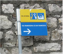
The Camino is designed to be self-guided (there are sign posts, paint markings, GPX tracks, and several good English guidebooks), but, upon request, we can also provide an accompanying guide.
Click here to read what previous participants have said about what the trail
Click here for more on the Way of Francis
Click here for the official website (in Italian)
Click here for the GPX tracks (recorded 2018)
Click here for the St. Francis Camino Guidebook
The Daily Stages
Stage 1: From Assisi to Foligno (easier route)
Distance: 20 kilometers
Cumulative increase in altitude: + 301 m
Cumulative loss of altitude: - 429 m
Surface: asphalt road, gravel road, dirt trail
Time: 5 hours
Difficulty: Moderate
Stage 1a: Assisi to Foligno (harder route)
Distance: 22 kilometers
Cumulative increase in altitude: + 925
Cumulative loss of altitude: - 1034
Surface: asphalt, gravel, dirt trails
Time: 8 hours
Difficulty: Very Difficult
Stage 2: From Foligno to Trevi
Distance: 13 kilometers
Cumulative increase in altitude: + 425 m
Cumulative loss of altitude: - 240 m
Surface: asphalt road, gravel roads
Time: 6 hours
Difficulty: Moderate
Stage 3: From Trevi to Poreta
Distance: 12 kilometers
Cumulative increase in altitude: + 410 m
Cumulative loss of altitude: - 430 m
Surface: asphalt road, gravel roads
Time: 5 hours
Difficulty: Difficult
Stage 4: From Poreta to Spoleto
Distance: 15 kilometers
Cumulative increase in altitude: + 520 m
Cumulative loss of altitude: - 500 m
Surface: asphalt road, gravel roads
Time: 5 hours
Difficulty: Difficult
Stage 5: From Spoleto to Ceselli
Distance: 17 kilometers
Cumulative increase in altitude: + 641 m
Cumulative loss of altitude: - 663 m
Surface: dirt trails, gravel roads, asphalt roads
Time: 7 hours
Difficulty: Experts Only
Stage 6: From Ceselli to Arrone
Distance: 16 kilometers
Cumulative increase in altitude: + 221 m
Cumulative loss of altitude: - 248 m
Surface: asphalt roads, gravel roads, dirt trails
Time: 5 hours
Difficulty: Easy
Stage 7: From Arrone to Piediluco
Distance: 14 kilometers
Cumulative increase in altitude: + 294 m
Cumulative loss of altitude: - 152 m
Surface: asphalt roads, gravel roads, dirt trails
Time: 4.5 hours
Difficulty: Moderate
Stage 8: From Piediluco to Poggio Bustone
Distance: 22 kilometers
Cumulative increase in altitude: + 978 m
Cumulative loss of altitude: - 662 m
Surface: asphalt roads, dirt roads, dirt trails
Time: 8 hours
Difficulty: Experts Only
Stage 9: From Poggio Bustone to Rieti
Distance: 18 kilometers
Cumulative increase in altitude: + 395 m
Cumulative loss of altitude: - 745 m
Surface: asphalt road, gravel roads, dirt paths
Time: 7 hours
Difficulty: Moderate
Stage 9a: From Rieti to Greccio (optional excursion)
Distance: 24 kilometers
Cumulative increase in altitude: + 470 m
Cumulative loss of altitude: - 390 m
Surface: asphalt roads, gravel roads, dirt trails, country roads
Time: 7.5 hours
Difficulty: Difficult
Stage 10: From Rieti to Poggio San Lorenzo
Distance: 22 kilometers
Cumulative increase in altitude: + 499 m
Cumulative loss of altitude: - 377 m
Surface: asphalt roads, gravel roads, dirt trails, country roads
Time: 7 hours
Difficulty: Moderate
Stage 11: From Poggio San Lorenzo to Ponticelli
Distance: 23 kilometers
Cumulative increase in altitude: + 821 m
Cumulative loss of altitude: - 1015 m
Surface: asphalt road, gravel roads
Time: 8 hours
Difficulty: Very Difficult
Stage 12: From Ponticelli to Monterotondo
Distance: 30 kilometers
Cumulative increase in altitude: + 690 m
Cumulative loss of altitude: - 871 m
Surface: paths, asphalt road, dirt roads
Time: 9 hours
Difficulty: Very Difficult
Stage 13: From Monterotondo to Monte Sacro
Distance: 19 kilometers
Cumulative increase in altitude: + 311 m
Cumulative loss of altitude: - 422 m
Surface: asphalt road, gravel roads
Time: 6 hours
Difficulty: Moderate
Stage 14: From Monte Sacro to St. Peter’s
Distance: 16 kilometers
Cumulative increase in altitude: + 158 m
Cumulative loss of altitude: - 168 m
Surface: urban sidewalks, bike paths
Time: 5 hours
Difficulty: Easy
Click the following links to watch Relive videos of each stage
Assisi-Spello (easy)
Assisi-Spello (difficult)
Spello-Trevi
Trevi-Poreta
Poreta-Spoleto
Spoleto-Ceselli
Ceselli-Arrone
Arrone-Piediluco
Piediluco-Poggio Bustone
Poggio Bustone-Rieti
Rieti-Greccio (optional)
Rieti-Poggio San Lorenzo
Poggio San Lorenzo-Ponticelli
Ponticelli-Monterotondo
Monterotondo-Monte Sacro
Monte Sacro-Roma
